
BY ELAINE GOODMAN
Daily Post Correspondent
A controversial proposal to build 16 homes on Laurel Way in Redwood City, which was shot down in San Mateo County Superior Court, may have new life now that an appeals court has overturned the lower court’s decision.
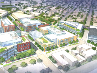
A group of residents called Save Laurel Way had protested the city’s approval in January 2014 of the new homes on 4.75 acres near the city’s Emerald Hills area. They said the development’s new road and cul-de-sac, 16-foot retaining wall, and new water, sewage, and electrical systems would create a significant impact on the surrounding community.
The homes would be built on a hillside with slopes as great as 45 degrees, increasing landslide risk, the group said in its lawsuit, filed in February 2014 against the city of Redwood City and Laurel Way Joint Venture, a group representing owners of the undeveloped lots.
“The project will transform an undeveloped, heavily wooded 4.75-acre open space area into a tightly packed residential subdivision over an unstable hillside,” Save Laurel Way said in its lawsuit.
Following a trial, the Superior Court in November 2015 rejected the city’s planned development permit for the project, zeroing in on the parcel map for the property. According to the court, the city had failed to evaluate the legal status of the lots under the state’s Subdivision Map Act. The lots were created in 1926 when the land was part of unincorporated San Mateo County. The city annexed the land in 1969.
“The facts and law do not support a finding that there are 16 legal lots upon which 16 homes can be built, and do not support a finding that the property owners have a vested right to develop each of the 16 alleged lots,” the trial court concluded.
Laurel Way Joint Venture took the case to the state Court of Appeal. And in its opinion, the appellate court pointed to a section of the Subdivision Map Act that says construction of a building can’t begin on a parcel that’s not compliant with the subdivision act. But the justices also noted that the project’s current permit isn’t for construction of the houses.

Instead, the permit is for the first phase of the project, which includes paving the roadway, installing utilities, sewer connections and drainage, building retaining walls, and adding landscaping. Construction of the homes would take place in a second phase, which would not begin until the first phase was completed and approved by the city’s community development director.
Jumping the gun
“While it appears the SMA’s (Subdivision Map Act’s) provisions may come into play as the individual members of LWJV move to construct homes on their properties, at this juncture any judicial pronouncements as to these issues is premature,” the justices wrote.
In light of its conclusion, the justices said they did not see a need to address other issues raised in the lawsuit. However, they did note that the Subdivision Map Act wouldn’t apply to the certification of environmental studies under California Environmental Quality Act, or CEQA.
Whether there’s been any further movement on the Laurel Way project since the appellate court decision wasn’t immediately known. In a section on development projects on the city of Redwood City’s website, the Laurel Way Joint Venture project is described as “on hold.”
The Laurel Way project dates back to at least 2006, when Laurel Way Joint Venture applied for a permit from the city. The city prepared an environmental impact report, or EIR, for the project, which was certified in August 2010.
But in September 2011, Laurel Way Joint Venture reduced the number of homes in the proposal by two, from 18 to 16, and a revised environmental report was prepared.
In March 2013, the city’s Planning Commission certified the project’s EIR, but said the homes should be smaller. The decision was appealed by the developers and residents: The developers wanted bigger houses, while neighbors opposed the overall project.
But the City Council upheld the Planning Commission decision, which would allow the Laurel Way homes to be about 2,503 square feet on average, with the largest being 3,343 square feet.
Council sided with developers
In January 2014, the council approved a resolution rejecting the appeals. The resolution stated that the lots in the Laurel Way project are non-conforming, meaning they don’t comply with minimum lot size in the city’s zoning ordinance “for such steeply sloped lots, most of which have slopes of 30% or more.”
In fact, if a new subdivision map was proposed for the land, the city’s current code would only allow the creation of four or five lots there, the resolution said.
But because the parcels existed before the city enacted its current zoning ordinance, development of the lots is possible if other zoning requirements are met and if lots with a slope greater than 30% go through a planned development permit process.
“No credible evidence has been presented to demonstrate that these lots are unlawful,” the city’s resolution stated.