
BY ELAINE GOODMAN
Daily Post Correspondent
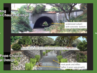
Replacing the Pope-Chaucer bridge as part of a flood control project for San Francisquito Creek would result in an approximately nine-month closure of the bridge, according to an environmental impact report.
During that time, construction crews would bring in jackhammers to break up the existing creek culvert, and excavators and trucks would remove the material. The creek flow would be diverted to protect it from construction activity, and tanks and pumps might be used to “dewater” the creek while a new bridge foundation is installed.
“It is anticipated that demolishing the existing bridge and building the new bridge will take approximately nine months, during which time vehicular, bike, and pedestrian traffic across San Francisquito Creek at this location would be interrupted,” said the draft environmental impact report prepared for the San Francisquito Creek Joint Powers Authority.
The JPA expects to get started on the creek project either next year or in 2021. The bridge would be closed starting in the spring, with work in the creek channel starting on June 15.
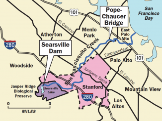
The San Francisquito Creek JPA was formed after the flood of February 1998, when the creek jumped its banks in several spots, damaging about 1,700 properties.
After completing projects downstream of West Bayshore Road, the JPA is now looking at a near-term project for the stretch between West Bayshore and the Pope-Chaucer bridge, an area the report refers to as Reach 2 of the creek.
The area is “the creek’s most densely populated region and the one that is now the most likely to flood,” the environmental report said. The public comment period is now open for the report, which was released last month.
Although the report looks at different alternatives for Reach 2, the JPA has chosen as its preferred plan the replacement of the Pope-Chaucer bridge along with widening of the creek channel in five locations.
Creek widening
Sacked concrete, concrete terracing and part of the creek bank would be removed in spots where the creek’s flow is constrained. In its place, a more vertical wall would be installed, which is held in place with “soil nails” that are embedded in the creek bank.
The creek-widening work is expected to take place over two construction seasons, from mid-June to mid-October. The construction period is restricted to protect the migration of steelhead trout, according to the report.
Replacing the Pope-Chaucer bridge, and widening the creek channel within Reach 2, would result in the removal of more than 23,000 cubic yards of dirt and concrete from inside the creek channel, the environmental report says. The average commercial dump truck holds anywhere from 10 to 14 cubic yards of dirt, according to the website for a soil and gravel delivery service.
But the amount of material from Reach 2 pales in comparison to how much might be removed for upstream flood water detention basins on Stanford land.
About 1.31 million cubic yards of material would be excavated for a detention basin at the former Boething plant nursery and another 1.04 million cubic yards for a detention basin at Webb Ranch, according to the draft environmental impact report.
“The detention basin would be dug with an excavator, and excavated material would be loaded into trucks for hauling to an offsite location for reuse or disposal,” the report states.
The detention basins are in an area the JPA calls Reach 3. The basins are viewed as a longer-term project that depends in part on what the university decides to do with Searsville Dam.
Slowing the water upstream
“While more difficult to achieve in the near term than a Reach 2 project, a project in the upstream areas of Reach 3 that results in the temporary detention of extreme flows is a critical piece of SFCJPA’s overall strategy to reduce risk and costs in our communities,” the report states.
So what happens to the material that’s dug up? According to the environmental report, non-recyclable, non-hazardous waste would go to the Sunnyvale Materials Recovery and Transfer Station and, from there, to either the Kirby Canyon Landfill in San Jose, the Monterey Peninsula Landfill in Marina, or Ox Mountain Landfill in Half Moon Bay.
The environmental analysis doesn’t expect that to have a negative impact on the landfills, which have a remaining capacity ranging from 27 million to 49 million cubic yards.
Public hearings on the draft environmental impact report are scheduled for:
• May 23 at the Laurel School Upper Campus in Menlo Park;
• May 29 at East Palo Alto City Hall;
• June 5 at the Palo Alto Art Center.
Each meeting will take place from 7 to 8:30 p.m.
In addition, written comments regarding the environmental report may be sent to [email protected]. Comments are due by June 19.
Only a fraction of the local news stories covered by the Daily Post appear on this website. To get all the local news, including many stories you can’t find online, pick up the Post every morning at 1,000 Mid-Peninsula locations.